 Live Music Archive
 Librivox Free Audio
 Metropolitan Museum
 Cleveland Museum of Art
 Internet Arcade
 Console Living Room
 Books to Borrow
 Open Library
 TV News
 Understanding 9/11
tv 9 News Now at 5pm CBS October 29, 2012 5:00pm-6:00pm EDT
5:00 pm

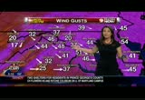
i want to toss it over to my colleague, meteorologist erica grow. she's going to tk about the wind gusts recorded now and i'll show you where we'll go over the course of the next 36 hours. >> the wind gusts continue to pick up. your eye, of course is, drawn to d.c. here and our report at reagan national is 52-mile an hour wind gusts right now. that's the strongest gusts we've had so far today at dca. 49 miles an hour in ocean city down from the peak gust i saw of 56. you can see up toward philly, new york, boston, tropical storm form wind gusts extending hundreds of miles with this storm. a closer look shows you wind gusts that we have throughout the d.c. metro continuing to show tropical storm force. at leesburg where it's 40 miles an hour now, 41 in manassas, 52 at dca, the big number on the map 44 in baltimore, 40 in annapolis. look at these wind gusts as we
5:01 pm
head across the bay, 48 miles per hour in easton now. i did see a peak wind gust earlier at virginia beach around 60 miles per hour. as the storm continues to move its track is expected to take it close to elgin, maryland and up toward lancaster, pennsylvania. it looks like the winds will continue to increase through the overnight hours. topper will talk more about that wind field. >> i wish we had better news, but we don't. it looks like it is going to strengthen and give us more damaging winds tonight through tomorrow morning. this is the hurricane force wind 7:00, a couple hours from now it. looks like pretty much the entire dell marv parks the bay, tidal -- delmarva, the bay, tidal potomac will be experiencing hurricane force warnings. there is a hurricane wind warning up for the tidal potomac and chesapeake bay. we'll take you into 2:00 this
5:02 pm
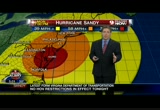
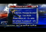
afternoon. pardon me? now the twin fields are essentially over the -- the wind fields are essentially over the immediate metro area. they've shifted south. these are hurricane force winds essentially from d.c. north to the border. that's winds 74 miles per hour or greater. we'll take you to 8 a.m. we still have an area of win 59, 60 to 70 -- wind 59, 60 to 70 miles an hour over much of the area. a bull's eye of hurricane winds is just northeast of cumberland. at 2 p.m. tuesday we still have tropical storm force winds everywhere through the carolinas, up through the mid-atlantic into new england, a massive storm. we get through tuesday night and finally into wednesday morning and by wednesday morning the tropical storm force winds will relax and move off to the north. we are looking at brand-new information there that brought a little more of the center of the hurricane force winds over the immediate metro area. sandy, what we know, she will be historic. pressure records, probably and
5:03 pm

again pressure is tied to intensity. intensity is tied to wind speeds, how strong the winds will be. critical now through tuesday afternoon, damaging winds 45 to 75 miles per hour, street and river flooding already occurring. erica just saw a picture from martinsburg. they've had as much as 5 inches of rain. leesburg wind impact up to 45 miles per hour and critical times through 2 p.m. tomorrow, 3 to 6 inches of rain. you already had about 4 1/2. frederick, maryland, 45 to 75 mile-per-hour winds, mainly talking about gusts, although we'll see sustained winds of 40, 50 and 60 miles per hour for a time. rainfall amount 3 to 6 inches. you've almost received that already. fairfax and the district 45 to 75 miles per hour 6 p.m. tonight till 2 p.m. tomorrow, rainfall amount 3 to 7 inches of rain. la plata, at least 65 miles per hour, perhaps to 70. i think you may just miss
5:04 pm

hurricane force winds. we're kind of slicing hairs here, 4 to 8 inches of rain critical through 2 p.m. tomorrow. annapolis 50 to 75 miles per hour that. might be blow. you could actually see an 80 mile-per-hour wind gust critical now through 2 p.m., critical now through 5 p.m., localized 5 inches. there's another band of rain that's hammering the delmarva now. it will cross the bay and move into the immediate metro area. look at the heavy rain back to the west through winchester and hagerstown, a lot of heavy rain through the i-81 corridor, 3 to 4 inches already recorded. heavy rain also out 66 westbound. we'll talk about the rainfall potential and put this into motion and you can see we're sort of at bull's eye now of anywhere from 5 to 6 inches of rain with the heaviest amounts from the district north through our northern suburbs into south central p.a. and across into philadelphia. this is quite a storm.
5:05 pm

it's going to be one for the record books. maybe it will be one of the storms of this century. got live press conference now with governor o'malley. >> the bad news is that the storm is becoming stronger in her center with 90-mile an hour winds. the good news is that she's moving faster. where we plan fall i think the current estimates are between 8 p.m. and 10 p.m. and the hope would be that she continues to move fast and moves on from maryland and passes over without stopping and hanging out and beating on us for 24, 36 hours. we currently have 75,000 outages in maryland and that number will climb. some of the other weather conditions that we're watching are these. we'll have flood warnings due to 5 to 6 inches of rain we've already received and we'll
quote

5:06 pm

likely receive another 4 inches overnight. the potomac will likely swell 1 to 3 feet above its normally it. we also have high tide at 8:25 p.m. tonight and i'm sure all of our friends in ocean city, that's a pretty vulnerable time for them at 8:25 tonight. we anticipate that high tide will be 6 feet higher than usual. garrett county will receive approximately 2 feet of snow. so how
5:07 pm

voting tomorrow. a few other key closures involve our bridges. the preston lane bridge better known to most of you as the bay bridge, the bay bridge is closed. the hatham bring in susquehanna also closed. the key bridge over 695 in baltimore is also closed. the tidings bridge is not closed. tidings
5:08 pm

operating tomorrow. light rail will be closed. marc trains will be closed. also the wamada bus is not operating today. mva branches, veep stations closed monday. paratransit will also not be operating tomorrow. we have 36 shelters open statewide. 36 of them are operated by local jurisdictions for them by the state. i really want to thank the following businesses who have contributed food to make sure that we have -- that we can accommodate people comfortably and they are wawa, sam's club and food lions. so thank you wawa, thank you sam's club and thank yofood lion. there are no reports currently for critical infrastructure damage. we'll be continuing to monitor that through the night. so in conclusion 75,000 outages so far, the storm is likely to
5:09 pm

make landfall sooner than we had thought because she is picking up speed along with picking up intensity. we expect land fall in new jersey -- steve, correct me if i'm wrong -- somewhere between 8 p.m. and 10 p.m. >> probably more like 8:00. >> more like 8 p.m. then the storm will make its way across maryland. so this is still a very violent and dangerous storm. we all need to act responsibly in order to minimize the potential for loss of life. this storm has already taken a lot of lives in the caribbean and now it's moving back onto land here in the united states in our most densely populated area. so please stay indoors. we're not trying to scare anyone, but we are being honest. this is a very, very dangerous storm and you need to stay indoors. one incident wanted to update you on in chrisfield, some of you go to the miller clam bake in the summer on. your way down there to your right as you walk into the
5:10 pm

parking lot, there is a housing community there called summers cove and with the tidal surge that came up in the last couple hours it raised the water level such that there's about 3 feet of water spread all over the ground floors of there summers cove. so various assets from the volunteer fire department to george johnson is here with us, to the dnr, police and their water assets are removing people from there. i don't know if you all have been in chrisfield when it rains even heavy or like this. that lower end tends to take on a lot of water, not unlike the downtown of ocean city in big rains. so we have a lot of people responding there and people are being evacuated from those homes to a shelter because their ground floors filled up with a lot of water. questions? yes, sir. >> reporter: the height of the storm will be hitting at night.
5:11 pm

any special concerns because of that? >> the height of the storm hitting at night, any special concerns. well, i think we're more likely all to be inors then. so in one sense i think that's probably good. we can't go out really to repair anything whether the power is knocked out in the middle of the night or the middle of the day. the key factor that determines whether or not we're able to send utility crews out there is the wind. so this is a night to kind of hunker down and be mindful of just what dangerous conditions we're under. >> that's maryland governor martin o'malley in a live press conference basically updating us in regard to where the state is. we've had 75,000 power outages in maryland so far, early voting is canceled tomorrow, and that there are 36 shelters statewide in case you need one.
5:12 pm

>> in garrett county they're dealing with the potential of up to 2 feet of snow. so between the rain, wind and snow the state of maryland will really take a hit from sandy. >> i've got to note this quickly. i got this from the folks at snowshoe mountain resort who are right in that garrett county area with regard to the area and they say we want to make sure everybody is safe, blah, blah, blah. on a positive note, though, we got notice and we may open early for thanksgiving. so it's not all bad. >> whether you can get there between now and then will be interesting. >> and whether the snow stays. >> absolutely. we'll take a quick break. we have more tracking sandy when we come back.

5:14 pm

we are back continuing to track sandy, the monster storm no longer quite a hurricane, sort of a hybrid cold core storm. >> she's nasty.
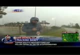
5:15 pm
whatever form she's taken it's pretty nasty doing some significant damage all over the place. our bruce johnson is barely hanging on there in rehoboth beach. looks like you're getting pelted and blown around a little bit, bruce. >> reporter: yeah. your bruce johnson almost ended up out in the middle of the ocean, lesli. not a high tide here. i don't know what that was about, an anomaly let's say. got a little good news, if you will. as sandy approaches cape may over to the north, the other side of the delaware bay, the rotation of this hurricane that's causing our winds to now come from the west. that's good news for most of us concerned about the erosion at the beach. that means the wind will be going out east that way, so it will be less erosion here. that's actually good news. there's nobody out here really. media reporting on this, there's mandatory evacuation. people are comparing this storm to a storm they had in the '20s. so they've taken it very seriously except for those people who did not take heed
5:16 pm

and are trying to get out of here now. the governor has said and police that you should shelter in place if you're not gone and if your in your homes, try not to be on the upper floors or near windows. one of the main concerns here at rehoboth beach is the high tide which normally comes in at 7:30. they don't want the hurricane to arrive at the same time as high tide because you've got a storm surge which will pick all this water up. that's what hurricanes do. they don't want that, the waves and the high tide to come on the the same time because that will put more water into the beach and downtown rehoboth and into people's basements. all tolls on the road have been waived. people out there are able to make their way without having to stop and pay money. we haven't had any reports of injuries and certainly no depths at this point. we have had an awful lot of reports of flooding. we've seen a lot of flooding especially over off the
5:17 pm

delaware bay. it's below sea level and just heavy flooding everywhere. we couldn't even pass through a lot of the rowways there. also as you go down -- roadways there. also as you go down route 1 toward dewey flooding there around dewey beach where the famous brewer ies or clubs as we can call them are. flooding on all those roads, water coming off the delaware -- make that the rehoboth bay and the bridge going eve to the indian river, that's -- over to the indian river. that's been closed off. so you cannot get from here to let's say south bethany and certainly not all the way south to ocean city because the road has been closed. at high tide the new indian river bridge, the water is almost up meeting the bridge. that is the situation here. we're wanting to point out it's cold because that cold front that's meeting this hurricane as it comes in, this is a cold
5:18 pm

wind. this is nothing like irene. irene was tropical, warm, no problem at all. this is actually cold, so not very comfort l, but you wouldn't want to -- comforting, but you wouldn't want to miss this, would you? >> bruce, get back with us. we want you on this side of the ocean, not in the ocean. andrea mccarren has been out all day on river road in bethesda. earlier she had the adventure of the blowing barriers. we'll find out where she is now. venezuelan? >> reporter: derek, we've had reinforcements here now. there's u.s. park police. the barriers have blown over to this side. there's some on the other side of the street. basically park police did the right thing. i think they've probably given up on them and they are planting a police cruiser in the middle of the intersection to prevent people from going down little falls parkway between river road and mass avenue. it is a very different bethesda
5:19 pm

that we're seeing right now. some of the wind guss have been extraordinary. look up river road now and you -- gust have been extraordinary. look up river road now and you will see there are no cars almost on the road, virtually every business here shut down, people heeding the warnings to get home before the worst of this storm hits. water is definitely pooling up on river road now. we've talked to some drivers who say branches are falling. there are a lot of power outages rolling through the area now. we have a very limited period of time that we can continue to be broadcasting safely from here. i'm going to show you what our issue is right here. i'm with colleague mark voss. he's going to turn around and show you the mast of our live truck. there have been some very precarious moments. you can see it just swinging in the wind now. i think probably for our safety this is about all the truck can handle. look at this intersection now. look at the sheets of rain just flowing through. if you can see across the
5:20 pm

street, the wind in the trees just completely bending them over. they're not snapping. they look like healthy trees. basically that's the scene here. good thing that people are heeding the warning. i think we'll probably be getting out of here fairly soon. again be safe out there. the few cars that are still going through, some of them still don't have their lights on. just a word of warning out there. i have to tell you my colleague mark voss, i asked him how tall are you? he said i don't know, 6' 2 or so. this is not a slight man. one of the wind gusts that came through when martin o'malley was speaking just about blew him across the street along with those barriers. so that should be a pretty good indicator about some of what we're up against out here. >> sounds a little shaky out there. i think you're right, it's time to bring that mast down and get to safety because no reporting
5:21 pm

is worth anybody getting hurt. get out of there. >> safety first to you and to mark. great job with them and all the crews out there braving the elements to bring this information back to our sures because the whole point is to keep -- viewers because the whole point is to keep people safe, keep them from going outside and hunker down. >> while you're hunkering we want to hear from you. go over to our facebook page, report your power outage, maybe some damage and we want those photos. >> then you can track the storm on twitter. follow us at wusa9 or topper at topper's weather, howard at hbwx or erica at erica grow. we're going to be right backtracking sandy.


5:24 pm

we're tracking sandy so you don't have to. >> that's right. you're stuck at home. you can't go outside. you're watching us. you're probably snacking, eating chocolate, doing all kinds of stuff. we want to know what you're doing. >> you're probably on your computer as you're watching us doing a little social media action. >> taking pictures, all that good stuff. our kristen berset and simon lando are going to share some of your pics and details. >> we've been getting tons of great pictures and videos today from all your viewers. we encourage you to keep sending them in. we really want toen what's
5:25 pm

going on in your area -- to know what's going on in your area as sandy gets closer. simon is here with me. we wanted to share with you guys this video we got earlier today. it's 4-year-old sophia campbell. she had some really great advice for all of you. simon, please play the video. >> this is great. we think you'll enjoy it. >> my name is sophia campbell. live from washington d.c. i'm on news with sandy. sandy can pick up houses, trees and even it can pick up people, umbrellas, trash cans. it can pick up a lot of stuff. >> so what should people do if near affected by the storm? -- they're affected by the storm? >> 911, that's what you call. >> a really brilliant girl there. again getting everything out of your yard, in all seriousness, she had some great advice,
5:26 pm

getting everything out of your yard, halloween displays, trash. keep it from getting picked up and flown around and becoming more of a missile. real quick this picture here our own dave owens sent this from chesapeake bay, virginia. a big tree knocked over from the house. luckily no one was hurt. also over in west virginia they're not getting rain. they're getting snow. look at this picture from mount storm lake, west virginia. as derek said earlier, snowshoe is getting lot of snow expecting up to 2 feet, might open before thanksgiving. so some great pictures and with the increased number of power outages want to remind you guys you can watch us all the time on the mobile app. what is the website people can go to for the mobile app? >> we'll be live streaming our video as you're watching here on our mobile app, but also on our mobile site m.wusa9.com. m is for mobile.wusa9.com.
5:27 pm

you go right on that site and you'll be able to click that live stream. please charge up now in case you lose power later and you'll be able to catch us when power goes out if it does.. >> a reminder, twitter, facebook, all the updated closings, school and metro closings and those of you stuck at home, if you get homesick or hungry, twitter is trending the hashtag open in d.c. those of you in d.c. can find a restaurant that's open. so for simon, i'm kristen berset. we'll be back with more of tracking sandy. >> now we're hungry. >> we'll be back in a minute.


5:30 pm
welcome back to 9news continuing coverage of hurricane sandy and as bad as it is out there now, it's only going to get worse. >> here is the latest, the federal government, d.c. government, d.c. public schools closed today and will be closed tomorrow. a lot of other school systems that hadn't announced they were cancelling classes tomorrow are doing so now. also metro will not resume service in the morning. they'll reassess and maybe later in the day, but then again maybe not. the flights out of reagan national and dulles have been canceled. the airports are open, but nothing is flying. you go out there, you'll just sit as well as regional amtrak service has been canceled until the storm goes by. >> . >> please don't go out there and sit. >> doesn't sound fun to me. >> let's get a look at sandy's
5:31 pm

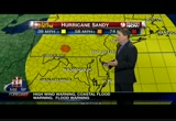
latest track. >> she is essentially making landfall as we speak probably just north of cape may and south of ocean city, new jersey. winds continue to increase. we have winds 90 miles per hour and we're looking at an incredible landfall and unlike most tropical systems, this won't weaken when it makes landfall. it's going to strengthen a little bit. it probably has already become a cold core storms which feed off temperature differences in the atmosphere as opposed to warm core storms which feed off warm surface temperatures. let's talk about wind and send it over to meterologist erica grow. >> you just talked about the difference between a warm core tropical system and the baroclinic system where you have the cold air starting to intrude into it and the fact we have the mountainous areas picking up snow will certainly indicate colder air is beginning to intrude into the system, but as of the 5 p.m. advisory national hurricane
5:32 pm
center is still calling this hurricane sandy with sustained winds at 90 miles per hour. this is where landfall is happening right about there in ocean city, new jersey. the wind field is very extensive, 51-mile an hour wind gusts at reagan national, 55 at ocean city, maryland, 31 miles an hour in albany, new york, and boston, 52-mile an hour wind gusts. so the tropical storm winds are way far away from the center of this storm. as it continues to move inland, we will see these wind gusts increase. right now this is just the tip of the iceberg, 48 miles an hour in leesburg, 44 in baltimore, 43 in annapolis, 48 miles per hour in easton and the big number on the map now is still at reagan national at 51 miles per hour. when you have those big winds, you have big waves as well. most of these numbers are right around 20 feet, put as we're watching the landfall of sandy, that's where the biggest waves are. that's the one good part about this storm, topper, as you know
5:33 pm

is that since we are on the side of the storm where the winds are coming from the west, we won't see as much storm surge, especially after this storm makes landfall. >> one silver lining, albeit kind of a thread of a silver lining. we're looking at winds blowing away from shore, but these waves are incredibly large. they'll continue to move a little closer to shore before they begin to back off. talking temperatures down to 46 in gaithersburg, 50 downtown, 46 in manassas and leesburg. here are the rain fields, another batch of very heavy rain encompassing most of the metro area, a little snow down into southwestern virginia and also southern west virginia around beckley. you guys are under a blizzard warning, believe it or not. a little snow is showing up out toward garrett county. we showed you savage mountain a while ago. that's going to get really hairy tomorrow, just starting right now. heaviest rain now running essentially on the east side of 270 through montgomery county up into frederick county.
5:34 pm
this will keep rotating, cross through 70, cross the river, head into fairfax and loudoun county in the next 20 minutes or so. here's the deal. sandy, she will be historic, pressure records, we've already seen a couple set. we have talk about that because that is a measure of the strength of the storm. that indicates how intense and high the winds can be. critical now through tuesday noon, may even have to extend that to 2 p.m. or 3 p.m. tuesday depending where you are. it's going to be critical longer north and west of town. damaging winds 45 to 75 miles per hour. we've already had street and river flooding and 4 to 12 inches of rain. sandy's impact, it's going take shingles off roofs, plus cal signs will be gone. -- political signs will be gone. street flooding monday evening, downed trees and limbs a given. local impact, leesburg winds 45 to 70 miles per hour, critical now through 2 p.m. tomorrow. frederick you'll have a hurricane force wind gust at
5:35 pm

least 45 to 75 miles per hour. you're critical from now through 2 p.m. tomorrow. we've extended critical times north and west of town. fairfax 45 to 70 miles per hour, also critical until early tomorrow afternoon. we give you these critical times, the winds won't go away after 2 p.m. this is the height of the storm, if you will. la plata, maryland, charles county, 40 to 65 mile-per-hour winds, 4 to 8 inches of rain. nap police 50 to 75 miles per hour -- annapolis, 50 to 75 miles per hour, 5 to 10 inches of rain are perhaps as much as 12 inches of rain before it's all done. please stay away from windows. supreme on the lower level. treat this as if it were a tornado warning. highest wind 40 to 75 miles per hour which is actually hurricane strength and critical now through we'll say tuesday, 2 p.m. that will encompass everybody to the north and also to the west of us as well. so we are not out of the woods. severe weather alert tomorrow
5:36 pm

and we're looking at code yell low, yellow weather alert wednesday, thursday, showers possible through thursday, still windy on wednesday. we just aren't going to be talking about 70-mile an hour winds. we'll be talking about 20 to 40 early and maybe 15 to 30 wednesday afternoon. >> it's a wrap for halloween. >> it's going to be tough for halloween, yeah. >> i got to ask you erica used a term i've never heard before. >> you just love her terms, don't you? >> this time she said it's a baroclinic storm. what does that mean? >> she's trying to teach us. >> in a couple minutes we'll come back and tell you what it is. >> we need the clip note version of it, the shortened version. we've been talking about flooding and peggy fox is in vienna. what's going on? >> reporter: well, take take
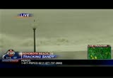
5:37 pm

look. this is wolf trap stream, i believe. that is flooding over top of old courthouse road and beasley road. we have seen cars both stop and ponder whether to drive through and turn away and we actually saw one vehicle -- i think it might have been a honda civic -- drive through it. i held my breath and they made it thank goodness. here comes a car in the distance. we don't know if they're going to -- we'll look at them as they come, but my goodness, you just really don't know how deep that is. it is so dangerous to try to cross places like this where the water is going over. here comes this car. oh, he's going to stop, taking a look. might see the news crew here. definitely a dangerous place. this is already at least 2 feet of flooded water here at the wolf trap stream and the winds are just picking up.
5:38 pm

things are falling down. debris is flying. there goes my umbrella flying away, very dangerous to be outside. thankfully that driver decided to turn around over there. the woods have now have been flooded, the creek is flooded over its banks, i don't know where the creek is actually. i can't really tell where the banks of the wolf trap stream is it's flooded so much. here comes a car. let's see if he comes through. looks like he's kind of determined there. oh, wow, that is really not the safest thing to, do my goodness. here's somebody else coming. wow are okay. so i don't know. here comes somebody. oh, my goodness. i feel like i want to go out
5:39 pm

there and tell them to turn around. that's a little car that could get washed away so easily. you know, last year after the hurricane lee waters i covered a story about a man, turned out to be the grandfather of a friend of my son's. he was a pizza deliveryman and he drove through a place like this and didn't make it. please don't do that. you don't know how deep that is. you don't know if you could go off on the side into a ditch and the current can take you away. it's just not worth it to save a little time. so look the flooded waters, it's just one of a dozen, a number of flooded areas at least in fairfax county area. please be safe and do not do what these cars. do back to you. >> you never know how deep that
5:40 pm

water is going to be. you've heard topper and erica warn everybody about the flash flooding. please couldn't do what that car did because you may not -- don't do what that car did because you may not make it out on the other side. the maryland transportation authority has should down several bridges including the bay bridge due to the storm where scott broom joins us live. you've got the mobile newsroom with you. what do you say? obviously won't be driving it across that bridge? >> reporter: yeah. reporting off a dashboard cam. listen, i've got to hold my head because the rain is swatting the goretex so sharply i can barely hear. you can see behind me the toll plaza at the bay bridge has been closed. it's been this way since quarter to 3:00 this afternoon. effectively the eastern shore has been cut off from the rest of the state. folks who are trying to get out of there, for instance, that time has long passed. only is this -- not only is this bridge closed, the hatham
5:41 pm
bridge is closed. there was a briefing for the governor of maryland a short while ago where he said the last big bridge out, the tidings bridge which goes across the susquehanna on 95 towards philadelphia he expects to close. i'm taking wind here and i'm in the lead of the car, so i'm trying to protect myself, but you may be able to get the feeling here that the wind is blowing consistently right around 40, 45 miles per hour out at -- miles per hour. out at the top of the bridge there are definitely gusts approaching 65 miles an hour. we are seeing the same things here at anne arundel county maryland as everybody else is seeing. there is lots of street flooding because of rainfall. there are lots of trees down and lot of wires down. this is why public safety officials are telling people to stay inside. they can look outside. maybe they want to try to make that drive to the gas station. the time is now passed for that. it's a very good chance of
5:42 pm

running into downed trees or wires or other things. they'll end up stranding you in the worst part of the storm. so now is not the time to go out and as you can see for practical purposes major infrastructure like u.s. route 50 here is closed. other major interstates through the region, there's now a mandatory speed limit of 45 miles per hour. [ audio difficulties ] we're here to inform the public, i.i. the media. in annapolis city the mayor has just announced in the last hour that he wants residents of annapolis because of the hurricane force winds expected to shelter in place from here on out, ride out the power outages. stay inside. for those who may get flooded out by tidal flooding or other problems, there's a shelter in annapolis at annapolis high school and other shelters elsewhere in anne arundel county like there are in other parts of the region.
5:43 pm

the eastern shore is cut off from the rest of the state as it has been for a couple hours and the winds continuing to increase. there is not a lot of traffic out anymore. people have heeded the warnings. they know this is no joke. reporting live at the foot of bay bridge on the western shore in anne arundel county, scott broom, 9 news now. >> thank you, scott. we know there's a hurricane going on and you broke up a couple seconds just when you were reminding everybody the speed limit is now 45 miles an hour statewide. if there's one thing that can cause an accident when you're out there, it's driving too fast for the conditions that are present. keep it down. keep it slow. get home safe if you have to go out. >> the good news is there haven't been a ton of people pot road. so people do appear to be -- on the road. so people do appear to be heeding the warning to stay safe and stay home if possible. we'll take a quick break and be right back.


5:47 pm

it's a 9news storm alert and it's going to be a storm alert for a while. >> this slow moving storm is sort of parking here and doing a number on our entire area. we have a report from the waterfront and it looks like the rain and wind is continuing now. >> reporter: it seems like it gets worse every time we have talk to you guys. when i walked out of the car, i stepped back to try to push the car door closed and it slammed behind me. you have to be very careful out here. i was telling you about the flags earlier. one of them disappeared. another one flew off. it's a very dangerous situation with the winds this high. those items become projectiles. there are fewer people out here which is a good time, but all day long in this type of situation we've seen a lot of people walking along here thinking it's okay to be outside in this weather. now it seems like there's a couple people left, but a lot fewer than there have within
5:48 pm

all day. on the ground you can see a couple covers for the latch posts are on the ground. so it's -- lamp posts are on the ground. so it's definitely a sign of things picking up. you can see a tree limb has fallen down as well. it's definitely becoming more and more dangerous. hopefully people are beginning to notice that and heading inside. it seems like a lot of students who have been out here going for runs in shorts and some of the things that we have seen have been pretty amazing considering how we've been dealing with it. you have rain pelting your face. i can barely stand in my position at certain times. at times i can't even open my eyes to look at the camera because the rain is hitting you so hard. the other situation is, of course, the water. we've been here since 10:30 this morning. the water hasn't gone up, but you can see it's very rough water at this point. it hasn't come up at all, but the walls are up, so if there is any flooding issues in this
5:49 pm

area, they are ready for that situation, but it's becoming more and more dangerous out here. the rain is pelting us and the wind is becoming stronger. as we've been sitting in our car waiting to come back out, we have been rocking side to side. again, those flags are disappearing. i'll send it back to you guys. >> thanks. we appreciate the effort out there in some very inclimate weather which is only going to get worse over the next several hours. >> we've been telling you for days to be prepared to lose your power because of this storm. our russ ptacek is monitoring the utilities and is he fining out about the late -- finding out about the latest power outage numbers. >> the numbers will come up in a second. about 15 minutes ago on twitter we exceeded 90,000 people in the metro without power. now this is going to bring up that system so you can go along with me as i'm showing you the power systems that we are
5:50 pm

monitoring. one of the interesting things we are looking at right now is that bge is having significant outages. i'm going to pull up bge now. this is the bge system. all those dots you see throughout here, those are people without power. we'll pull this up. so this is the total statewide in maryland, 55,000 customers from bge without power. you'll see 10,000, 19,000 in baltimore county, 6,000 baltimore city, anne arundel county more than 5,000 people, montgomery county 1,800, prince george's county 2,600. now let's look at prince george's and anne arundel so you can get an idea all those dots in those areas identifying outages there. pepco's numbers moved up, too. pepco is now looking at 21,000 customers without power. we'll pull over to the map so you can see everywhere that one of those zip code areas is
5:51 pm

colored in, that means they have outages. when we started out today, there would only be one or two or three of these with color. now we're seeing lot of color. let's pull up that area around potomac and see what information we can get in zip code 20854, about 1,000 people without power. dominion in northern virginia. dominion is reporting more than 28,000 people without power. novak now, we'll look at their map. we'll move right into one of those outages, see what information we can get on that, if that pulls up. on that particular one that was reported at 4:17 this afternoon. see, these are so -- look at this. these are so specialized. i had these all up on my facebook page. you can look up and do these yourself, but in this case that's an outage involving only one customer. so about 1,300 customers for
5:52 pm

novak reporting outages. right now smeco reporting 3,300 without power. the biggest county area near reporting problems, st. mary's county. of course, prince george's is about 90. we'll cover these numbers throughout the evening and we are having more people without power. back to you guys. >> thank you, russ. we will check in with you periodically just to figure out if the lights are on at our house. we got a little information posted around 5:30 about the huntington area in fairfax county which can have some flooding. people on two streets were told they had to evacuate immediately on february wick drive and arlington terrace. they're going to turn -- on fenwick drive and arlington terrace. they're going to be turning the power off. so it's essential for them to leave. you can count on us to give you the information you need to make it through hurricane sandy. we're tracking sandy. we'll bring you the latest coming up after the break.


5:55 pm

welcome back as 9news continues to track hurricane sandy or cold core storm or intense cyclone or baroclinic storm. we have been getting live reports from our bruce johnson in rehoboth beach, dell
5:56 pm

degrees. >> reporter: this is bruce johnson. you -- in delaware. >> reporter: this is bruce johnson. you can see the water. it's close to 4 feet deep here. the rehoboth bay has spilled over to the road here and every road heading that way toward downtown rehoboth beach. come this way. i want to show you something. dickinson street here, postal highway is the main drag. if you go the whole way you get to ocean city, maryland, but before you have to cross the indian river bridge and it's blocked off there. coastal highway dewey beach, it stops and you can't go further because of flooding. it's been that way the past 24 hours. come back around this way, the atlantic ocean. you have got the surge everybody is talking about that will be several feet high when sandy comes through. add to the surge the tide, add the waves and you're talking a lot of water that's going to be
5:57 pm

coming over the dune there onto these roads and all of this you can imagine will be impassable later this evening 5 p.m. through tonight. [ audio difficulty ] >> bruce johnson, amazing stuff all day long. thank you, bruce. >> everybody pushing the boundaries of technology through the storm. we're going to take a quick break. we are still tracking sandy all night long. we'll be back.


221 Views
IN COLLECTIONS
WUSA (CBS) Television Archive
  Television Archive News Search Service
Uploaded by TV Archive on
